Ngalau Tarang in Agam Regency, West Sumatra Province
Tourists are likely to enjoy hiking and exploration when visiting Agam Regency. It is true that the region is known for its highlands. Still, more interesting vacation spots are available to explore including caves. One of them is called Ngalau Tarang, which is located in Kamang Magek Sub-District. To be exact, this cave resides in Kamang Mudiak Village. In terms of name, “Ngalau” means cave and “Tarang” means bright. The location is near to Ngalau Kalam or the Dark Cave. That means tourists can visit two astonishing caves, which are located in the same area! They only need to come with a local guide who knows the route well. So, what makes Tarang special?
The Nuance
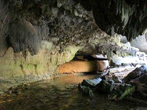
Ngalau Tarang is located on a limestone hill. This explains why the cave is dominated by limestone landscapes. Unlike Kalam Cave, Ngalau Tarang is brighter inside. It is because the sunlight passes through the cave. Thus, visitors won’t be difficult in order to explore the cave at noon. However, they need a flashlight when exploring it in the afternoon. The access to the cave is considered easy, but everyone needs to walk from the nearby village to the entrance of the cave. The distance is around 100 meters.
Exploring Ngalau Tarang
As mentioned before, the distance between Ngalau Tarang and local settlement is quite near. That means tourists won’t waste too much energy to get there. Once arriving at the entrance, tourists may see a wide cave mouth! What about the interior? Like other caves, this one features both stalagmites and stalactites. The wall is made of natural limestone indeed and it looks so exotic. Due to the beauty, it is recommended to take some photos while exploring the cave later.
When it comes to the appearance, Ngalau Tarang looks like an ancient cave. This indeed lures nature lovers and photographers. Moreover, caving can be done easily due to the bright ambiance. However, the best time to explore the cave is at noon or bright day. Aside from the stalagmites and stalactites, the cave is known for its small river that passes through some parts of the area. The water is clear and refreshing. However, swimming is prohibited. The locals want to retain the clarity of the river, after all.
After exploring Ngalau Tarang, tourists must not forget to drop by in the neighboring cave called Ngalau Kalam. However, this one is quite dark and damp. That means everyone should carry a flashlight when exploring the cave. For beginners, in this case, they should not explore it without a guide!
Nearby Attractions
- Kalam Cave
- Tarusan Kamang
- Tirtasari Park
- Kelok Ambacang Malalak
How to Get There
From Jakarta City, tourists only need to take an airplane service at Soekarno – Hatta International Airport and head to Padang City right away. For the information, during normal weather, a flight to Minangkabau Airport would take around 1 hour and 40 minutes. Once arriving at Padang, the next destination is Agam Regency and it can be done by taking Maninjau – Lubuk Basung Street. The distance is 109 km, so this trip may take around 2 hours and 15 minutes. From Agam, it is recommended to take Padang Lua – Maninjau Street and head to the cave immediately. The distance is 52.3 km, so the trip would take around 1 hour and 43 minutes.
Where to Stay
- Kompphil Guesthouse
- Pakankamih Guesthouse

Visiting Bukittinggi City in West Sumatra Province, Indonesia
What do tourists know about Bukittinggi City? Well, most of them recognize it as the capital of West Sumatra Province belongs to Indonesia. Some of them are even aware of its tourism potential, so they keep coming to the region over time, especially during long holidays. Not only it becomes the governmental center of West Sumatra, the city was once the capital of West Sumatra and Sumatra Province! Moreover, in the past, it was called Fort de Kock and known as the birthplace of a famous person named Mohammad Hatta…
Enjoying The Great View at Langkisau Hill, West Sumatra
Langkisau peak tourism object is located at the edge of the koto Painan with a height of about 500 meters above sea level and it offers an inspiring beauty. Langkisau peak is an area of excellent Pessel which have tourism potential that should be developed, because this area is at a height so that people who visit will be able to see the beautiful scenery and fascinating about the city Painan and Sago District IV of Jurai. At night, will be more lively enchanted by beautiful night scenery that…
Siberut Island, The Home Of Mentawai Tribe – West Sumatra
Siberut Island Becomes part of Mentawai Islands, Siberut is the largest island at the northernmost and becomes the main important island for Mentawai People. The Mentawai tribe still maintains the lifestyle and traditions passed down from their ancestors from thousands of years ago. They live in houses locally called ‘uma’, made from wooden scaffolds which house contains several families each. Siberut is located in the Indian Ocean, approximately 100 km off the west coast of West Sumatra, and separated from the main island by the Mentawai Strait. The island…
The Old Town Sawahlunto, West Sumatra
Sawahlunto is one of provinces in Indonesia, precisely in West Sumatera, Indonesia. This town is located in 95KM Northeast of Padang and surrounded by 3 districts in West Sumatera, which is Tanah Datar, Solok and Sijunjung. Sawahlunto is divided into 4 sub-districts and it has 273,45 km², with populated by 54.000 people. During Dutch civilization, Sawahlunto was popular as coal mining town. After being a death town, during the closing of the mining, Sawahlunto nowadays becomes the growing city with multi-ethnicity inside the community, and awarded as the best old…